Welcome to Frankfurt. Today, our adventure includes exploring an interactive map of Frankfurt, Germany, designed to assist you in navigating the city along the River Main. Let’s dive in without delay.
Overview of Frankfurt
When you think of Frankfurt, Germany, the image that likely comes to your mind is that of a bustling metropolis in the heart of Europe. Known as a global financial center in Central Europe, Frankfurt is a city with a rich history and a vibrant present.

Located in the federal state of Hesse, Frankfurt is among the largest cities in Germany. It proudly stands as an urban district with its roots deeply embedded in Europe’s cultural and economic spheres. As a free city, Frankfurt has long been at the forefront of economic activities and is a critical node for commerce and finance.
In terms of population, Frankfurt is a diverse and growing city, as people from all over the world continue to converge here, contributing to its status as a global city. Moreover, here’s a quick look at some key aspects:
| Aspect | Detail |
|---|---|
| Population | Over 700,000 residents within the urban area |
| Language | German |
| Currency | Euro (€) |
| Time Zone | Central European Time (UTC+1) |
| Airport | Frankfurt am Main Airport |
| Landmarks | The Römer, Goethe House, Frankfurt Cathedral |
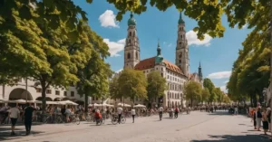
Whether you’re in Frankfurt for its world-class financial institutions, the historical landmarks, or just to soak up its cosmopolitan atmosphere, you’ll find this city has an endless supply of energy and charm. If you’re here for business or tourism, don’t forget to explore the dynamic skyline contrasted with old-world buildings that have withstood the test of time.
Geography and Climate
Exploring Frankfurt, you’ll find its unique geography and climate shaped by the River Main and the surrounding Taunus mountains. It’s a place where elevation plays a key role in weather patterns.

Topography

Frankfurt is nestled on both sides of the River Main, which is a defining topographic feature of the city. The city’s elevation varies, featuring flat riverbanks that rise into gentle hills as you reach the Taunus mountain range to the north.
| Feature | Description |
|---|---|
| River Main | The central watercourse running through Frankfurt, pivotal for trade |
| Elevation | Ranges from 100m to 300m above sea level across the city |
| Taunus | Low mountain range contributing to Frankfurt’s diverse topography |
Climate Data
Frankfurt’s climate is a blend of continental and maritime influences, producing cold winters and warm summers. Your experience of the weather will depend on both the time of year and the specific areas of the city due to its varied elevation.
| Month | Avg. High (°C) | Avg. Low (°C) | Precipitation |
|---|---|---|---|
| January | 4 | -1 | 40 mm |
| July | 25 | 14 | 60 mm |
The climate here is often described through its seasonal weather patterns, with the surrounding Taunus mountains sometimes shielding the city from extreme weather, while other times, they can lead to rapid changes in weather conditions.
Transportation Networks

Exploring Frankfurt, you’ll notice it boasts an extensive transportation network, seamlessly connecting various modes like buses, trains, and trams. The Frankfurt Hauptbahnhof serves as a pivotal hub, and public transit options are abundant, ensuring that whether you’re traveling by plane or bike, your journey within the city will be straightforward and efficient.
Frankfurt Hauptbahnhof

Frankfurt Central Station, commonly known as the Frankfurt Hauptbahnhof, is the heart of the city’s transport. It’s one of the largest railway stations in Europe, making it a crucial node for rail services throughout Germany. Here, you can catch high-speed trains, regional trains, and the S-Bahn, which connect you effortlessly to destinations like the Frankfurt Airport and the Niederrad business district.
| Transportation Mode | Available Services |
|---|---|
| Train | High-speed, Regional, S-Bahn |
| Bus | Local, Long-distance |
| Taxi | Ranks available outside the station |
| Bike | Rental stations and dedicated pathways |
Public Transit Options
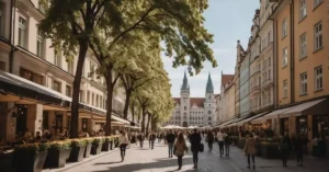
As you navigate Frankfurt’s public transit system, you’ll find buses, trains, and trams ready to take you to your next stop. The Rhein-Main-Verkehrsverbund (RMV) ensures that a single ticket can span multiple modes of transport. Whether you’re taking a quick tram ride to Zeil shopping street or relying on the efficiency of the U-Bahn to avoid traffic, Frankfurt’s network is designed to be user-friendly and comprehensive.
- Bus: Extensive network reaching all areas of the city.
- Train: Connects to major cities and regions, with the Lufthansa Airport Shuttle for air travelers.
- Tram: Offers scenic routes through the city’s core and beyond.
- Plane: Frankfurt Airport, a major international hub, links you with destinations worldwide.
- Bike: Take advantage of the Call a Bike service for an eco-friendly tour around the city.
If you’re planning to stay for a while or aiming to experience the city’s vibrant nightlife, consider grabbing the Network map Night travel FrankfurtRheinMain for a snapshot of how transportation services adapt after hours. And whenever in doubt, the local taxi service is just a wave away, ready to take you to your Frankfurt adventure.
Cultural Landmarks and Attractions

Exploring Frankfurt’s cultural landmarks and attractions is a journey through exquisite art galleries, historical sites, and landmarks that tell the story of this vibrant city. Your Frankfurt map will come in handy as you uncover the rich tapestry of cultural experiences awaiting you.
Museums and Art Galleries

Frankfurt is home to a plethora of museums and art galleries, each offering a unique window into the worlds of art, history, and culture. At the heart of the city’s art scene is the Städel Museum, housing seven hundred years of European art. From classical to modern pieces, it’s a treasure trove that you can’t miss.
Another key player on the cultural map is the Museum of Modern Art. Known for its captivating contemporary works, it offers an intriguing contrast to the classical pieces found at the Städel.
Museums and Art Galleries in Frankfurt:
| Attraction | Description |
|---|---|
| Städel Museum | European art spanning 700 years |
| Museum of Modern Art | Contemporary art exhibitions |
Historical Sites

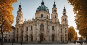
When you’re in Frankfurt, stepping into the past is as simple as wandering through the cobblestone streets of Römerberg, the old town center. The historic heart of Frankfurt, Römerberg hosts the iconic Frankfurt Cathedral, a Gothic masterpiece that dominates the skyline.
The Goethe House, birthplace of the famed writer Johann Wolfgang von Goethe, allows you to delve into the literary history of Germany. Its restored rooms and artifacts rekindle the spirit of the past.
For an atmospheric evening, consider a visit to the Alte Oper, a grand opera house where performances still echo the glamour of bygone days.
Historical Sites in Frankfurt:
- Römerberg – The historic old town square with the Römer town hall.
- Frankfurt Cathedral – A towering Gothic church with rich history.
- Goethe House – Preserved home of Germany’s famous literary figure.
- Alte Oper – Opera house and cultural venue for performing arts.
As you navigate through the city with your Frankfurt map, these cultural landmarks and attractions offer a captivating glimpse into the soul of this German metropolis. Whether you’re drawn to the timeless art in the museums or the echoes of history at the sites, each moment spent in these places will enrich your understanding and appreciation of Frankfurt.
Economic Significance

When you look at Frankfurt on a map, its size might not immediately reveal its towering stature as an economic powerhouse. But don’t be fooled—this city is the beating heart of Germany’s financial life.
Banking and Finance

Frankfurt is recognized as a premier financial centre, playing host to major institutions such as the European Central Bank and the Deutsche Bundesbank, the central banks that frame the financial policies affecting not just Germany, but the entire Eurozone. It’s where monetary decisions that steer the economic course of Europe are made, and its influence is profound.
At the heart of the city lies the Frankfurt Stock Exchange, one of the world’s largest securities trading centers, accounting for over 90% of Germany’s turnover in this sector. Moreover, Frankfurt’s status as an ‘alpha world city‘ in the Globalization and World Cities Research Network (GaWC) 2008 inventory underpins its global significance.
In the central business district, you’ll find the headquarters of Commerzbank as well as a dense network of financial services, including numerous commercial banks. This area is the engine room of Germany’s economic activity and a pivotal axis in the global financial system.
| Frankfurt’s Economic Entities | Description |
|---|---|
| European Central Bank | Sets monetary policy for the Eurozone and is based in Frankfurt. |
| Deutsche Bundesbank | Germany’s central bank, instrumental in the country’s economic stability. |
| Frankfurt Stock Exchange | Among the world’s largest trading centers. |
| Commerzbank | One of the largest commercial banks with headquarters in Frankfurt. |
| Central Business District | The hub of economic activity in the city. |
| Alpha World City | Classification indicating Frankfurt’s global economic importance. |
Whether working in investment banking or stopping by for a business meeting in one of its towering skyscrapers, you’re participating in a storied tradition of commerce that has helped to shape the modern world. Frankfurt’s financial district truly is a place where today’s economic pulse is felt.
Local Infrastructure

Exploring the local infrastructure of Frankfurt through its city map gives you a clear view of the well-thought urban planning and the spread of residential areas. This glimpse into the city’s design reflects how both residents and visitors navigate and experience Frankfurt.
Urban Planning
Frankfurt’s urban planning is a testament to meticulous design and organization. The city’s streets are laid out in a way that facilitates easy access to various districts and key locations. Here’s a glance at some of the standout features of Frankfurt’s urban planning:
- Streets: Well-structured and interconnected, ensuring smooth transit.
- Location: Centralized hubs promote a blend of commercial and cultural activities.
You’ll find that hotels and other amenities are strategically placed within reach, supporting both tourism and local convenience.
Residential Areas

Residents of Frankfurt enjoy a range of living spaces, from bustling city center apartments to quieter suburban homes. Here’s a quick snapshot:
| Area Type | Characteristics | Notable Locations |
|---|---|---|
| Inner City | Densely populated, high-rise buildings | Near Zeil shopping street |
| Suburban Neighborhoods | Family-friendly, spacious homes with green spaces | Niederrad, Bornheim, and Sachsenhausen |
These areas are meticulously planned to offer a blend of accessibility to city amenities while providing a comfortable living space. Take a look at the Frankfurt city map, and you’ll see how residential zones are integrated seamlessly with the rest of the city’s infrastructure.
Our Opinion about Frankfurt Germany Map
We hope that you can benefit from this somewhat different map and get to know Frankfurt from great new angles. In our opinion, Frankfurt is worth a visit Frankfurt is one of the most important German cities waiting to be explored. Take a look at these articles about places to visit in Frankfurt, the Best Hotels in Frankfurt, and about the Frankfurt skyline and get to know the city better.
FAQ about Frankfurt Germany Map
What are the top tourist attractions in Frankfurt?
Top tourist attractions in Frankfurt include Römerberg, the city’s old town center, Städel Museum, and the Palmengarten. A Frankfurt Germany map can help locate these sites.
How do I navigate the public transportation system in Frankfurt?
Navigate Frankfurt’s public transportation using subways, trams, and buses. Detailed guidance is available on the Frankfurt public transportation guide to help you travel efficiently.
Where can I find the best shopping and dining options in Frankfurt?
For shopping and dining, Skyline Plaza and Old-Sachsenhausen offer nearly 200 stores and a variety of restaurants. Use a Frankfurt Germany map to explore these areas.
Did you missed something on our interactive Frankfurt Germany Map? Let us know in the comments below and keep in touch with us. See you soon.